
For the third time during my week long trip to Utah, I got caught out in hail, thunder, and lightning that came uncomfortably too close. This particular storm opened up on us in the Uinta Mountains, during a backpacking trip with Gregory Mountain Products to test out the new line of packs and generally decompress in good company after Outdoor Retailer.
THE GEAR
Maps: For less that $15 with Trimble Outdoors, you can create your own personalized, waterproof topo map for the exact section of terrain you plan to explore. You can see our trip here.

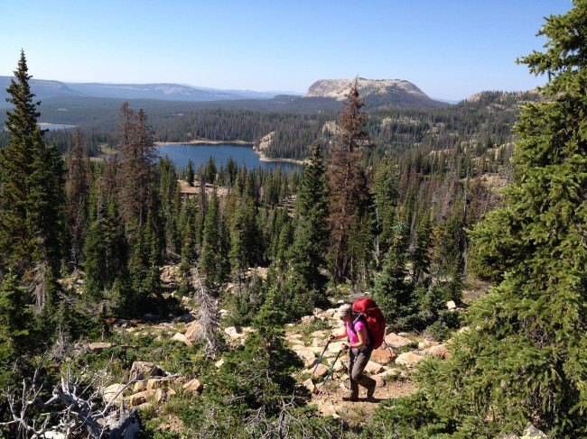
Gregory Baltoro/Deva ($299-$349): Available in 60L-85L capacities, the fully redesigned backpacking packs feature the brand new Response A3 suspension system. Adjustable torso length, independently pivoting shoulder harness and hipbelt panels, along with a ventilated center back panel make for a comfortable carry even with heavy loads. One of coolest features—the Sidekick pack, an internal hydration reservoir compartment that doubles as an ultra-light removable daypack for summit bids. Full review to follow.
Big Agnes mtnGLO Tent: Light emitting diodes (LEDs) integrated directly into the construction of a tent. Way better than your tent partner constantly shining his headlamp in your face.
Chaco Layna Waterproof Hiker ($130): The water-resistant suede and mesh construction with a waterproof bootie came in handy when I fell into Ibatnik Lake. The women’s-specific LUVSEAT PU footbed and a shank-supported EVA midsole offered up all day comfort—and no blisters even with out of the box wear. I didn’t slip once when scrambling over steep, wet rocks or muddy terrain thanks to the Active Adventure non-marking rubber outsole.
Our itinerary included a two night stay at the picturesque Ibantik Lake. Following the Notch Mountain Trail, we hiked in the roughly 6 miles from the Bald Mountain Trailhead and exited over Notch Pass to the Crystal Lake Trailhead (approx. 4 miles). On the day in between, we explored the surrounding peaks (East and West Notch), fished the pristine alpine lakes, bouldered on the enormous rock chunks flanking Notch Mountain, and just generally enjoyed being outside.

When Salt Lake City is hot and dry, the Uinta Mountains, less than 1 ½ hours away, offer up a cooler yet sometimes wet respite. Temperatures in areas above 10,000 feet seldom get above 80 degrees during summer days, while night temperatures hover around a blissful 30-40 degrees. Summer afternoon thunderstorms may (and most definitely do!) occur with little warning.
Most of the Uinta Mountain Range is contained within the Ashley National Forest. However, we were exploring the western portion that lies within the Wasatch-Cache National Forest. The High Uintas Wilderness was established by Congress in 1984 and includes 460,000 acres—the largest wilderness area in Utah.
Not something you would come to associate with Utah—there are well over 1,000 natural lakes and over 400 miles of streams in the Uintas, where more than 500 of them support populations of game fish. Over 2.5 million visitors come to the Uintas each year, where popular activities include fishing, hiking, backpacking, horsepacking, and even hunting. Much of the area is blissfully designated as a roadless wilderness where vehicles are prohibited.
Elevations range from 8,000 feet in the lower canyons to 13,528 feet atop Kings Peak—the highest point in Utah. Ridges divide the area into large, scenic basins, making this ideal backpacking territory, whether you want to head out for one night or many.
- Single night option: Some of the best fishing in the mountains can be found at the end of a simple 5-7 mile backpack. Pack in, set up camp, and you still have several hours of daylight to fish and explore. Fish found in the Uintas include arctic grayling, brook trout, brown trout, cutthroat trout, golden trout, and rainbow trout.
- Two to three night option: Pack into one of the more distant basins. Make basecamp, then day-hike to the top of King’s Peak.
- Full cross-country trips: Start at a North Slope trailhead and have someone pick you up at a South Slope trailhead, or vice-a-versa. Or hike for 50 miles or more along the Highline Trail, which runs east-west across much of the wilderness area.

Permits: You need a use permit to explore the Uintas. These can be obtained from the rangers at the entrance stations located along the major roads into the region. The permits are charged by car for the number of days you plan to be out. A Utah State Fishing License is also required if you plan to fish in the Uintas.
When to go: You can explore the Uintas year round. Although Hwy 150 is closed in winter, the wilderness area is popular amongst backcountry skiers, cross country skiers, snowmobilers, and snowshoers.
Food: There are no bear safety requirements apart from being smart about food storage—beware the chipmunks and large herds of mountain goats. If you want to backpack in style, you can hire guide Nathan Smith’s company, Mountain ED, who will pack in your food and cook your meals for you. It’s pretty luxurious to wake up to your coffee and breakfast already made.
Now that I know all what is on offer, the Uintas will be a permanent part of my post-Outdoor Retailer travel plans.